Real-time telemetry · SPW station 6832 Trois-Ponts · Official ODWB status · Updated every 15 min
🌲 Salm water level today
Flow and water height measured at Trois-Ponts, official navigation status of the reach « downstream of the Vielsalm dam ». Navigation allowed from 1 October to 15 March, up to 9.7 m³/s.
Last recorded reading: 2026-09-29 at 17:00 · Sources: SPW Hydrométrie and ODWB
Salm flow over the last 30 days
Each bar shows the average daily flow at Trois-Ponts, calculated from the SPW's hourly values. The dashed red line marks the 9.7 m³/s legal maximum when it fits within the scale; days above it are shown in red.
Over the period: minimum 0.31 m³/s, maximum 0.55 m³/s, average 0.37 m³/s. The legal maximum (9.7 m³/s) is off the scale: the river is far below it.
What does the current Salm flow mean?
The regulations set only two things: the period (1 October – 15 March) and the maximum flow (9.7 m³/s). To help you read today's figure, we added indicative benchmarks based on the station's official statistics since 1987 (median 2.2 m³/s, 10% of the time below 0.84 m³/s, 10% of the time above 7.3 m³/s). The highlighted row matches the current flow (0.29 m³/s).
| Flow (m³/s) | Level | In season | Interpretation |
|---|---|---|---|
| 0.0 – 0.84 | Very low water | Barely paddleable | Below the level reached one time in ten (low water). The pebble bed shows everywhere: constant scraping, frequent portages. |
| 0.84 – 2.2 | Low water | Technical | Below the median flow. Passable in places but the riffles are thin; for light, patient paddlers. |
| 2.2 – 5.0 | Medium water | Good level | Around and above the median: enough water over the ledges, lively and readable current. The best compromise in season. |
| 5.0 – 9.7 | High water | Sporty | Powerful current, waves on the ledges, harder to correct. Experienced kayakers only, never alone. |
| > 9.7 | Flood | Forbidden | Above the 9.7 m³/s legal maximum: navigation forbidden for the day. |
Outside the legal period the Salm is closed whatever the flow: the « In season » column only applies between 1 October and 15 March.
Regulations: when and how to paddle the Salm
Kayaking on Walloon rivers is governed by the Walloon Government decree of 19 March 2009 regulating traffic on and in watercourses. It sorts rivers into three groups: navigable waterways (Annex 1.A), rivers open all year (1.B) and those that only open in the cold season (1.C). The Salm belongs to this last category, alongside the Warche downstream of the Robertville dam, the Houille, the Our and the Sûre.
📅 Period and hours
- Navigation only allowed from 1 October to 15 March.
- Every day between 10:00 and 17:00 (hours of Annexes 1.B and 1.C from October to mid-June).
- Forbidden on the opening day of the trout-fishing season, the third Saturday of March — which sometimes falls on 15 March.
- Reach concerned: the Salm downstream of the Vielsalm dam (lac des Doyards) to Trois-Ponts.
💧 Flow conditions
- Observation point: Trois-Ponts station.
- No minimum flow for the Salm in Annex 2.
- Maximum flow: 9.7 m³/s. The day is closed if the observed hourly mean flow exceeds it, or if the 8 a.m. forecast announces an exceedance during opening hours.
- The minister may also restrict navigation at any time to protect nature or manage the watercourse.
Boats and launching
Only kayaks and canoes for up to three people, inflatable boats for up to ten people and rafts of recognised youth organisations are allowed, without engines. Launching and landing are only permitted at designated areas: you do not put in from any bridge or garden, and private banks must be respected. Clubs affiliated to the Royal Belgian Canoe Federation also hold a ministerial exemption (decree of 14 December 2020) for their winter training on the Salm, subject to a height of at least 57 cm on the Trois-Ponts gauge: it does not apply to rental companies or individual paddlers.
Who decides the daily status?
Every day, reach by reach, the Public Service of Wallonia decides whether navigation is allowed or forbidden, and publishes the result as open data on the ODWB platform (« Circulation sur les cours d'eau en Wallonie » dataset, reach code SALM). That official status is what the banner at the top of this page shows. We cross it with the legal period and the Trois-Ponts flow: if any of the three conditions is not met, the page shows « navigation forbidden ». When in doubt, the SPW's decision and the signs posted at the launch areas always prevail.
SPW station 6832 at Trois-Ponts
Hydrometric station DGH/6832 « Trois-Ponts » monitors the Salm at the lower end of the village, just before the river flows into the Amblève. A sensor records the water height several times an hour; the SPW converts it into flow using a rating curve that is regularly checked by field gaugings. The values are published under an open licence and collected by our server every 15 minutes, which is why the figures on this page may lag a few minutes behind the raw measurement.
Over its whole observation period (since 1987), the station gives a mean flow of 3.3 m³/s and a median flow of 2.2 m³/s. The gap between the two reveals the Salm's character: long spells of modest water, broken by short but strong floods that pull the average up. Ten percent of the time the flow stays below 0.84 m³/s; ten percent of the time it is above 7.3 m³/s; and the 9.7 m³/s legal maximum is only exceeded on about one day in twenty.
The height shown is the reading of the station's gauge, in metres above its zero: it is not the depth of the river. The same flow can also match different heights from one year to the next if the bed changes. Base your decision on the flow and the official status rather than on the height.
For the Amblève, which the Salm flows into, the reference is the Stavelot station, upstream of the confluence: check the Amblève water level for the Coo descent, which follows its own rules (open all year between 1 and 21 m³/s).
The Salm, a river of the Vielsalm Ardennes
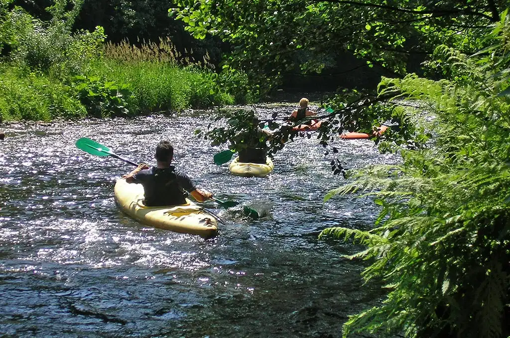
The Salm rises at Beho, on the Gouvy plateau, at around 530 metres. It flows 34 kilometres north through Courtil, Bovigny, Honvelez, Cierreux, Salmchâteau, Vielsalm and Grand-Halleux, before joining the Amblève at Trois-Ponts. Its catchment covers 202 km², split between the provinces of Luxembourg and Liège. Along the way it receives the Ronce, upstream of Salmchâteau, and the Golnay.
Its name is thought to come from the Celtic salwa, « dark, murky ». The valley gave its name to the former County of Salm, still remembered in Vielsalm (« old Salm ») and Salmchâteau. The area is also known for coticule, a yellow whetstone quarried from its slate and exported worldwide. At Vielsalm a dam holds back the river to form the lac des Doyards: the reach open to kayaks starts at this dam.
Between Vielsalm and Trois-Ponts the Salm becomes a lively river with a bed of pebbles and slate, small ledges and tight bends under spruce and beech. As a headwater river it reacts very quickly: after heavy rain on the plateau, its flow can multiply within hours, then drop almost as fast. That liveliness is its charm in winter, but it means checking the flow on the morning of your trip.
Routes and landmarks on the Salm
The regulated reach runs from the Vielsalm dam to the confluence at Trois-Ponts. Three descents come up most often, all heading downstream:
- Vielsalm → Trois-Ponts (about 14 km): the full route, for experienced paddlers, with a string of technical passages in a heavily wooded valley.
- Grand-Halleux → Trois-Ponts (about 8 km): the section white-water fans like best, with ledges and small rapids.
- Lower reach to Trois-Ponts (about 5 km): a first taste of the river before it meets the Amblève.
Launch and landing points must be areas designated by the SPW; check with your rental company or the authorities before setting off. For a full presentation of the river, the routes and the season, read our guide kayaking the Salm and the Viroin. And if the Salm is closed, the nearby Amblève descent at Coo stays open all year depending on its flow.
Weather for the coming days in the Ardennes
The Salm responds quickly to rain: a marked rainy spell on the Vielsalm plateau raises the flow as early as the next day, sometimes above the legal maximum. Conversely, a few dry days bring it back down. Regional forecasts:
🌧️ 0.0 mm
💨 14 km/h
🌧️ 4.1 mm
💨 14 km/h
🌧️ 6.7 mm
💨 7 km/h
🌧️ 0.0 mm
💨 5 km/h
🌧️ 0.0 mm
💨 9 km/h
Safety: paddling the Salm in the cold season
The Salm opens precisely when the water is coldest. Between November and March its temperature often drops below 8 °C: falling into water that cold takes your breath away and your hands lose their dexterity within minutes. Preparation matters far more than on the Semois in summer.
- Thermal clothing: a neoprene wetsuit or technical clothing that stays warm when wet, shoes, gloves or pogies, and a full set of dry clothes in the car.
- Buoyancy aid and helmet: pebbles and ledges make a helmet essential on a river like this.
- Never alone: paddle with at least two boats and tell someone your route and arrival time.
- Trees and barbed wire: after a flood, trunks can block the river. Get out and scout any doubtful passage.
- Hours: in winter night falls early; the 17:00 legal limit leaves little margin, so start early.
For questions about flow, gear and weather that apply to every river, see also our reference page on navigable flows in Wallonia.